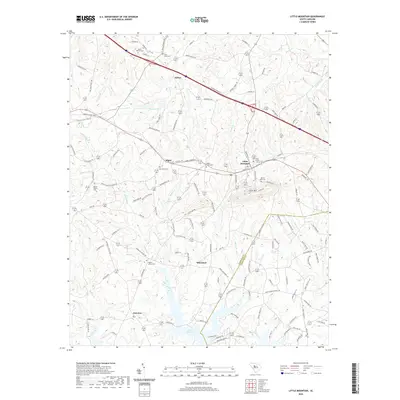
2020 Map of Little Mountain
USGS Topo · Published 2020About this map
Lake Murray dominates the southern landscape of this Newberry and Lexington County border region, its northern inlets reaching toward the settlements of Wheeland and Fairview. The terrain is defined by the namesake Little Mtn, which rises above the town of Little Mountain, a community centered around the intersection of Main St and the historic rail corridor. Numerous family and community burial grounds, such as Mount Hebron Cem and Mount Zion Cem, are distributed across the countryside, reflecting the area's deep-rooted settlement patterns. Further north, the communities of Slighs and Kibler sit near Crims Cr and Eptings Pond. The map reveals a dense network of local roads and tributaries, including Camping Cr and Mayer Cr, which feed into the larger reservoir to the south.
Find a feature on this map
141 named features on this map. Tap any name to fly to it.
Don’t see what you’re looking for? This feature index may not catch every label — zoom into the map to look around manually.
Map Details
Editions of this 2020 Little Mountain Map
This is the sole edition of this map. No revisions or reprints were ever made.
Other maps of this area

1904 · Columbia
USGS Topo · 1:125,000

1941 · Spartanburg
USGS Topo · 1:250,000

1953 · Spartanburg
USGS Topo · 1:250,000

1960 · Spartanburg
USGS Topo · 1:250,000

1963 · Spartanburg
USGS Topo · 1:250,000

1964 · Spartanburg
USGS Topo · 1:250,000

1968 · Newberry East
USGS Topo · 1:24,000

1969 · Pomaria
USGS Topo · 1:24,000
1969 · Jenkinsville
USGS Topo · 1:24,000
1970 · Prosperity
USGS Topo · 1:24,000