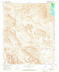
1965 Map of Little Picacho Peak
USGS Topo · Published 1966About this map
Little Picacho Peak stands as the primary landmark in this desert landscape, overlooking an intricate network of drainage channels that define the arid terrain of Imperial County. The eastern edge of the map follows the Colorado River corridor, where the Imperial National Wildlife Refuge encompasses the waters of Ferguson Lake. This 1965 survey reveals a terrain shaped by both natural erosion and human extraction, with numerous prospects and the Hess Mine located near the headwaters of various washes. The network of seasonal watercourses, including Senator Wash, Marcus Wash, and Mission Wash, dictates the movement across the land, often paralleled by unnamed jeep trails used by mineral explorers. The presence of Gravel Pits in the southeast corner near the river reflects the ongoing infrastructure and industrial activity necessary for managing the border region's resources during the mid-1960s.
Find a feature on this map
17 named features on this map. Tap any name to fly to it.
Don’t see what you’re looking for? This feature index may not catch every label — zoom into the map to look around manually.
Map Details
Editions of this 1965 Little Picacho Peak Map
2 editions found
Other maps of this area

1903 · Yuma
USGS Topo · 1:125,000

1905 · Yuma
USGS Topo · 1:125,000

1929 · Laguna
USGS Topo · 1:62,500

1939 · Red Hill
USGS Topo · 1:62,500

1942 · Yuma
USGS Topo · 1:250,000

1942 · Blythe
USGS Topo · 1:250,000

1943 · Laguna
USGS Topo · 1:62,500

1945 · Picacho Peak
USGS Topo · 1:62,500

1945 · Picacho
USGS Topo · 1:62,500

1951 · Picacho
USGS Topo · 1:62,500