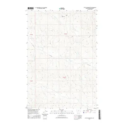
2017 Map of Little Pilgrim Butte
USGS Topo · Published 2017About this map
Little Pilgrim Butte dominates the northern landscape of this Powder River County terrain, serving as a prominent landmark above a complex network of seasonal drainages and draws. The drainage pattern is particularly intricate here, with Little Pilgrim Cr and Poker Jim Cr cutting through the northern sections while Pilgrim Cr and Hay Cr snake through the central and southern reaches. This modern topographical survey highlights the remote character of southeastern Montana, where infrastructure is limited to a few arterial tracks like Pilgrim Creek Rd and Moore Rd. For those tracing local history or family ties to the land, the presence of Edwards Spring and named features like Strock Draw and Jim Drake Cr provide specific points of reference in an area defined by its hydrology and landform rather than urban development.
Find a feature on this map
18 named features on this map. Tap any name to fly to it.
Don’t see what you’re looking for? This feature index may not catch every label — zoom into the map to look around manually.
Map Details
Editions of this 2017 Little Pilgrim Butte Map
This is the sole edition of this map. No revisions or reprints were ever made.
Other maps of this area

1954 · Ekalaka
USGS Topo · 1:250,000

1956 · Ekalaka
USGS Topo · 1:250,000

1958 · Ekalaka
USGS Topo · 1:250,000

1965 · Ekalaka
USGS Topo · 1:250,000

1973 · Monday Creek
USGS Topo · 1:24,000

1973 · Hawkey Creek
USGS Topo · 1:24,000
1973 · Fighting Butte
USGS Topo · 1:24,000

1979 · Deer Creek Buttes
USGS Topo · 1:24,000

1979 · McKenzie Creek
USGS Topo · 1:24,000

1980 · Broadus
USGS Topo · 1:100,000