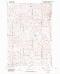
1982 Map of Little Pilgrim Butte
USGS Topo · Published 1982About this map
Little Pilgrim Butte anchors this landscape in eastern Montana, where the drainages of the Powder River basin reveal a complex network of seasonal watercourses and springs. During the mid-1970s and early 1980s, the area's hydrology was marked by several critical water points, including Edwards Spring and a Flowing Well, vital for ranching and land use in this arid region. The drainage patterns are defined by named features such as Little Pilgrim Creek, Sage Hen Creek, and Papoose Creek, which carve through the terrain toward the larger Pilgrim Creek. This survey also documents early energy exploration markers through scattered Drill Hole locations, alongside traditional landmarks like Strock Draw and Jim Drake Creek, illustrating the intersection of natural geography and human resource assessment in Powder River County.
Find a feature on this map
18 named features on this map. Tap any name to fly to it.
Don’t see what you’re looking for? This feature index may not catch every label — zoom into the map to look around manually.
Map Details
Editions of this 1982 Little Pilgrim Butte Map
This is the sole edition of this map. No revisions or reprints were ever made.
Other maps of this area

1954 · Ekalaka
USGS Topo · 1:250,000

1956 · Ekalaka
USGS Topo · 1:250,000

1958 · Ekalaka
USGS Topo · 1:250,000

1965 · Ekalaka
USGS Topo · 1:250,000

1973 · Monday Creek
USGS Topo · 1:24,000

1973 · Hawkey Creek
USGS Topo · 1:24,000
1973 · Fighting Butte
USGS Topo · 1:24,000

1979 · Deer Creek Buttes
USGS Topo · 1:24,000

1979 · McKenzie Creek
USGS Topo · 1:24,000

1980 · Broadus
USGS Topo · 1:100,000