
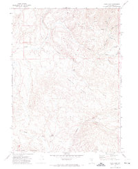
1973 Map of Little Rock Creek
USGS Topo · Published 1977About this map
Rock Creek Shearing Corral serves as a focal point for the ranching activity that defined this high desert landscape in Elko County during the early 1970s. The terrain is characterized by a dense network of seasonal drainages, including Little Rock Creek, Coyote Creek, and Soldier Creek, which converge as they flow toward the larger Rock Creek. To the south, the prominent Willow Creek Ridge rises above the basin, while localized Hot Springs and numerous unnamed springs indicate the area's geothermal and hydrological complexity. Human presence is marked by a sparse infrastructure of Jeep Trails and scattered prospects, reflecting an economy built on livestock management and mineral exploration. The presence of multiple corrals and shearing pens suggests a seasonally active range where shepherds and ranchers gathered stock from the surrounding drainages like Trout Creek.
Find a feature on this map
18 named features on this map. Tap any name to fly to it.
Don’t see what you’re looking for? This feature index may not catch every label — zoom into the map to look around manually.
Map Details
Editions of this 1973 Little Rock Creek Map
This is the sole edition of this map. No revisions or reprints were ever made.
Other maps of this area

1955 · McDermitt
USGS Topo · 1:250,000

1956 · Mt. Blitzen
USGS Topo · 1:62,500

1959 · McDermitt
USGS Topo · 1:250,000

1965 · Willow Creek Reservoir
USGS Topo · 1:24,000

1965 · Squaw Valley Ranch
USGS Topo · 1:24,000
1970 · China Camp
USGS Topo · 1:24,000

1974 · Soldier Cap
USGS Topo · 1:24,000

1974 · Burner Hills
USGS Topo · 1:24,000

1977 · Scraper Springs
USGS Topo · 1:24,000

1982 · Tuscarora
USGS Topo · 1:100,000