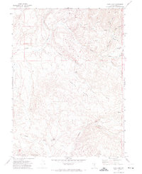
1970 Map of China Camp
USGS Topo · Published 1974About this map
The northern reaches of the Santa Renia Mountains dominate this high-desert landscape, where seasonal water sources dictate the geography of the Great Basin. This 1970 field-checked survey reveals a rugged network of drainage systems including Willow Creek, China Creek, and Soldier Creek, all which rely on a series of critical watering holes like Alkali Springs and Chicken Spring. The terrain is characterized by steep contours and isolated landforms such as Antelope, suggesting a region primarily utilized for seasonal livestock grazing rather than permanent settlement.
Find a feature on this map
18 named features on this map. Tap any name to fly to it.
Don’t see what you’re looking for? This feature index may not catch every label — zoom into the map to look around manually.
Map Details
Editions of this 1970 China Camp Map
This is the sole edition of this map. No revisions or reprints were ever made.
Other maps of this area

1955 · McDermitt
USGS Topo · 1:250,000

1956 · Mt. Blitzen
USGS Topo · 1:62,500

1959 · McDermitt
USGS Topo · 1:250,000

1965 · Willow Creek Reservoir
USGS Topo · 1:24,000
1965 · Willow Creek Reservoir SE
USGS Topo · 1:24,000

1970 · Sugarloaf Butte
USGS Topo · 1:24,000
1970 · Santa Renia Fields
USGS Topo · 1:24,000
1970 · Beaver Peak
USGS Topo · 1:24,000

1973 · Little Rock Creek
USGS Topo · 1:24,000

1982 · Tuscarora
USGS Topo · 1:100,000