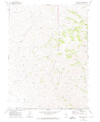
1970 Map of Beaver Peak
USGS Topo · Published 1974About this map
The Tuscarora Mountains dominate this high-desert landscape in Elko and Eureka Counties, rising to the prominent summit of Beaver Peak. This 1970 field-checked survey reveals a remote ranching and mining environment defined by seasonal water sources and rugged trails. Evidence of early human activity is scattered throughout the drainages, including Ruins found along an unnamed fork of Boulder Creek and several Corral sites positioned near vital Spring locations. To the south, the terrain descends into Little Boulder Basin, where a solitary Prospect indicates the mineral exploration common to this part of Nevada. The drainage network is particularly detailed, tracing the paths of Squaw Creek, Toro Canyon, and Coyote Creek as they carve through the steep mountain slopes. A network of Jeep Trails provides the primary access through this high-altitude range, connecting isolated landmarks like Bell and various livestock enclosures.
Find a feature on this map
21 named features on this map. Tap any name to fly to it.
Don’t see what you’re looking for? This feature index may not catch every label — zoom into the map to look around manually.
Map Details
Editions of this 1970 Beaver Peak Map
This is the sole edition of this map. No revisions or reprints were ever made.
Other maps of this area

1955 · McDermitt
USGS Topo · 1:250,000

1955 · Winnemucca
USGS Topo · 1:250,000

1958 · Winnemucca
USGS Topo · 1:250,000

1959 · McDermitt
USGS Topo · 1:250,000

1962 · Winnemucca
USGS Topo · 1:250,000

1968 · Rodeo Creek NE
USGS Topo · 1:24,000

1968 · Swales Mountain NW
USGS Topo · 1:24,000

1968 · Rodeo Creek NW
USGS Topo · 1:24,000

1970 · Sugarloaf Butte
USGS Topo · 1:24,000

1970 · Lake Mountain
USGS Topo · 1:24,000