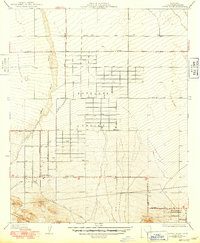
1934 Map of Little Rock
USGS Topo · Published 1949About this map
Antelope Valley agriculture and desert settlement define this landscape during the mid-century period of expansion in Los Angeles County. The map details the emerging grid system of Little Rock and Pearblossom, where orchards and homesteads rely on the Little Rock Ditch and numerous irrigation wells for survival in the arid terrain. The geographic character is dominated by the Little Rock Wash, a wide alluvial channel that cuts through the valley floor, while the southern edge of the sheet is marked by the distinct geological presence of the San Andreas Rift Zone. Historical transit routes like the Pear Blossom Highway and Fort Tejon Road reflect the importance of this corridor for regional travel between the high desert and the Los Angeles basin. This survey, revised in the 1940s, captures the exact placement of early desert infrastructure and family-owned parcels before modern suburban development.
Find a feature on this map
10 named features on this map. Tap any name to fly to it.
Don’t see what you’re looking for? This feature index may not catch every label — zoom into the map to look around manually.
Map Details
Editions of this 1934 Little Rock Map
4 editions found
Other maps of this area

1900 · Tujunga
USGS Topo · 1:62,500

1901 · Southern California Sheet No. 1
USGS Topo · 1:250,000

1903 · Rock Creek
USGS Topo · 1:62,500

1904 · Southern California Sheet No. 1
USGS Topo · 1:250,000

1915 · Elizabeth Lake
USGS Topo · 1:125,000

1917 · Elizabeth Lake
USGS Topo · 1:125,000

1930 · Lovejoy Springs
USGS Topo · 1:24,000

1930 · Little Rock
USGS Topo · 1:24,000

1930 · Llano
USGS Topo · 1:24,000

1930 · Pearland
USGS Topo · 1:24,000