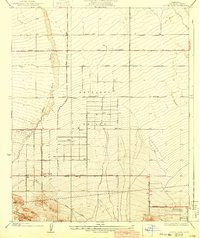
1934 Map of Little Rock
USGS Topo · Published 1943About this map
Antelope Valley occupies the heart of this 1930s topographic study, revealing the early agricultural and transportation infrastructure established on the high desert floor. The settlement of Little Rock serves as a primary hub, defined by a rigid grid of avenues and the Little Rock Ditch, which speaks to the critical importance of water management in this arid landscape. The southern portion of the map is dominated by the dramatic topography of the San Andreas Rift Zone, where the land rises sharply away from the valley floor toward Cima Mesa. Transportation routes such as the Pear Blossom Highway and the Fort Tejon Road navigate the transition between the flat alluvial plains and the complex geological formations to the south. This survey captures the region before mid-century suburban expansion, highlighting a landscape of scattered wells and nascent desert communities like Pearblossom.
Find a feature on this map
15 named features on this map. Tap any name to fly to it.
Don’t see what you’re looking for? This feature index may not catch every label — zoom into the map to look around manually.
Map Details
Editions of this 1934 Little Rock Map
4 editions found
Other maps of this area

1900 · Tujunga
USGS Topo · 1:62,500

1901 · Southern California Sheet No. 1
USGS Topo · 1:250,000

1903 · Rock Creek
USGS Topo · 1:62,500

1904 · Southern California Sheet No. 1
USGS Topo · 1:250,000

1915 · Elizabeth Lake
USGS Topo · 1:125,000

1917 · Elizabeth Lake
USGS Topo · 1:125,000

1930 · Lovejoy Springs
USGS Topo · 1:24,000

1930 · Little Rock
USGS Topo · 1:24,000

1930 · Llano
USGS Topo · 1:24,000

1930 · Pearland
USGS Topo · 1:24,000