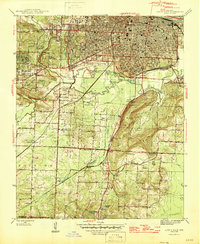
1944 Map of Little Rock
USGS Topo · Published 1946About this map
Douglasville and the southern reaches of Little Rock are defined by a complex grid of 1940s neighborhoods and intersecting rail lines. The landscape is structured by the Fifth Principal Base Line, where rural life meets industrial growth. Near the winding Fourche Creek, the presence of the Granite Quarry and various rail junctions like Hot Springs Junction and Biddle highlight the era's logistical importance. Smaller communities such as Geyer Springs and Ironton are dotted with local institutions, including Liberty Ch, Spring Hill Ch, and the Base Line Sch. To the north, the urban core is anchored by Fair Park and extensive burial grounds at Oakland Cem and Calvary Cem, while the southern terrain rises into Echo Valley near the border of Pulaski and Saline counties.
Find a feature on this map
37 named features on this map. Tap any name to fly to it.
Don’t see what you’re looking for? This feature index may not catch every label — zoom into the map to look around manually.
Map Details
Editions of this 1944 Little Rock Map
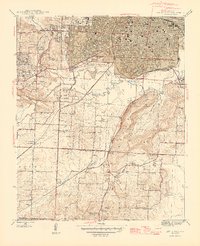
2 editions found
Other maps of this area

1891 · Little Rock
USGS Topo · 1:125,000

1893 · Little Rock
USGS Topo · 1:125,000

1935 · Mc Almont
USGS Topo · 1:24,000

1935 · Little Rock
USGS Topo · 1:24,000

1935 · Sweet Home
USGS Topo · 1:24,000

1935 · North Little Rock
USGS Topo · 1:24,000

1935 · Alexander
USGS Topo · 1:48,000

1940 · Woodson
USGS Topo · 1:31,680

1941 · Alexander
USGS Topo · 1:62,500

1943 · Pinnacle Mtn
USGS Topo · 1:31,680
Featured Places
- Little Rock, AR
- North Little Rock, AR
- Brittain, Little Rock
- Yorkwood, Little Rock
- American Manor, Little Rock