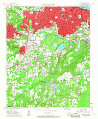
1961 Map of Little Rock
USGS Topo · Published 1962About this map
Little Rock is mapped here during a period of rapid suburban expansion, with the central urban core concentrated north of Fourche Creek while new developments like Wakefield Village, Cloverdale, and Meadowliff push south into the woodlands. The map documents significant institutional landmarks, including the State Capitol, the Arkansas School for Deaf and Blind, and several historic educational sites such as Central High Sch and Philander Smith College. Industrial and transit activity is concentrated along the Missouri Pacific and Chicago Rock Island and Pacific railroad lines, which navigate the terrain between Granite Mountain and Brodie Mountain. To the south, the landscape shifts toward extractive industry and rural infrastructure, evidenced by numerous Mines, a large Quarry, and the state Fish Hatchery near the Pulaski and Saline County line. The density of named cemeteries, from Mt Holly Cem to the National Cemetery, provides an essential record for local genealogical research.
Find a feature on this map
120 named features on this map. Tap any name to fly to it.
Don’t see what you’re looking for? This feature index may not catch every label — zoom into the map to look around manually.
Map Details
Editions of this 1961 Little Rock Map
3 editions found
Other maps of this area

1891 · Little Rock
USGS Topo · 1:125,000

1893 · Little Rock
USGS Topo · 1:125,000

1935 · Mc Almont
USGS Topo · 1:24,000

1935 · Little Rock
USGS Topo · 1:24,000

1935 · Sweet Home
USGS Topo · 1:24,000

1935 · North Little Rock
USGS Topo · 1:24,000

1935 · Alexander
USGS Topo · 1:48,000

1940 · Woodson
USGS Topo · 1:31,680

1941 · Alexander
USGS Topo · 1:62,500

1943 · Pinnacle Mtn
USGS Topo · 1:31,680
Featured Places
- Little Rock, AR
- North Little Rock, AR
- Brittain, Little Rock
- Yorkwood, Little Rock
- American Manor, Little Rock