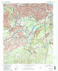
1986 Map of Little Rock
USGS Topo · Published 1986About this map
Little Rock’s urban expansion and industrial legacy are documented in this mid-1980s topographical study, showing a city structured by major transit corridors like Interstate 630 and the Missouri Pacific railroad. The map highlights the concentration of civic and medical infrastructure, including the State Capitol and Arkansas Childrens Hospital, alongside neighborhoods such as Geyer Springs and Wakefield Village. South of the urban center, the landscape shifts toward industrial and resource extraction areas, marked by Inactive Strip Mines and Iron Ore Hill.
Find a feature on this map
76 named features on this map. Tap any name to fly to it.
Don’t see what you’re looking for? This feature index may not catch every label — zoom into the map to look around manually.
Map Details
Editions of this 1986 Little Rock Map
2 editions found
Other maps of this area

1891 · Little Rock
USGS Topo · 1:125,000

1893 · Little Rock
USGS Topo · 1:125,000

1935 · Mc Almont
USGS Topo · 1:24,000

1935 · Little Rock
USGS Topo · 1:24,000

1935 · Sweet Home
USGS Topo · 1:24,000

1935 · North Little Rock
USGS Topo · 1:24,000

1935 · Alexander
USGS Topo · 1:48,000

1940 · Woodson
USGS Topo · 1:31,680

1941 · Alexander
USGS Topo · 1:62,500

1943 · Pinnacle Mtn
USGS Topo · 1:31,680
Featured Places
- Little Rock, AR
- North Little Rock, AR
- Brittain, Little Rock
- Yorkwood, Little Rock
- American Manor, Little Rock