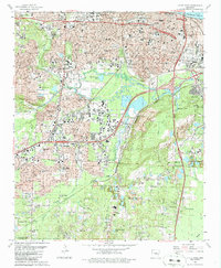
1986 Map of Little Rock
USGS Topo · Published 1986About this map
The State Capitol and the urban heart of Little Rock dominate this mid-1980s landscape, illustrating the city's complex institutional and educational layout. Historic campuses like Philander Smith College and Arkansas Baptist College sit alongside iconic landmarks such as Central High Sch and the extensive Oakland Cemetery and National Cemetery. The industrial and transport history of the region is etched into the terrain, from the Missouri Pacific rail corridors to the southern edges where Inactive Strip Mines and Quarry sites mark the transition from city streets to the resource-rich hills.
Find a feature on this map
101 named features on this map. Tap any name to fly to it.
Don’t see what you’re looking for? This feature index may not catch every label — zoom into the map to look around manually.
Map Details
Editions of this 1986 Little Rock Map
2 editions found
Other maps of this area

1891 · Little Rock
USGS Topo · 1:125,000

1893 · Little Rock
USGS Topo · 1:125,000

1935 · Mc Almont
USGS Topo · 1:24,000

1935 · Little Rock
USGS Topo · 1:24,000

1935 · Sweet Home
USGS Topo · 1:24,000

1935 · North Little Rock
USGS Topo · 1:24,000

1935 · Alexander
USGS Topo · 1:48,000

1940 · Woodson
USGS Topo · 1:31,680

1941 · Alexander
USGS Topo · 1:62,500

1943 · Pinnacle Mtn
USGS Topo · 1:31,680
Featured Places
- Little Rock, AR
- North Little Rock, AR
- Brittain, Little Rock
- Yorkwood, Little Rock
- American Manor, Little Rock