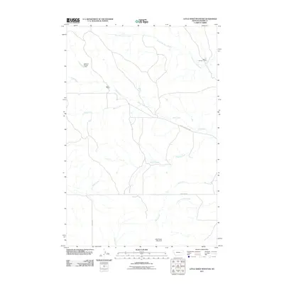
2011 Map of Little Sheep Mountain
USGS Topo · Published 2011About this map
Devlin Ranch sits at the heart of this Montana prairie landscape, marking a site of human habitation in a region defined by its complex drainage network. The terrain is dominated by the prominence of Little Sheep Mountain to the south, while the hydrological system is anchored by Cherry Creek and its various tributaries. Water management is evident through the inclusion of the McDevlin Number 2 Dam and Keltner Number 1 Dam, which indicate the importance of water storage for ranching or agricultural operations in this arid environment. Roads such as North Cherry Creek Rd and Caprock Rd provide the primary access through the undulating country, following the natural contours shaped by North Fork Cherry Creek and South Fork Cherry Creek. These features illustrate the sparse but deliberate footprint of ranching life in Prairie County during the early 21st century.
Find a feature on this map
15 named features on this map. Tap any name to fly to it.
Don’t see what you’re looking for? This feature index may not catch every label — zoom into the map to look around manually.
Map Details
Editions of this 2011 Little Sheep Mountain Map
This is the sole edition of this map. No revisions or reprints were ever made.
Other maps of this area

1953 · Miles City
USGS Topo · 1:250,000

1954 · Glendive
USGS Topo · 1:250,000

1957 · Miles City
USGS Topo · 1:250,000

1957 · Glendive
USGS Topo · 1:250,000

1958 · Miles City
USGS Topo · 1:250,000

1958 · Glendive
USGS Topo · 1:250,000

1965 · Little Sheep Mountain
USGS Topo · 1:24,000

1965 · Heitz School
USGS Topo · 1:24,000

1965 · Twin Buttes School
USGS Topo · 1:24,000
1965 · Combs Ranch
USGS Topo · 1:24,000