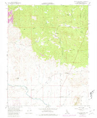
1962 Map of Little Table Mountain
USGS Topo · Published 1981About this map
San Joaquin Experimental Range occupies the northeastern reaches of this landscape, where the foothills of Madera County meet the valley floor. The map highlights a rural infrastructure of named ranching outposts and historic stopping points, including the notable Twentytwo Mile House and the Zebra Station. These sites, along with the Wide Awake Ranch and Shaubach Ranch, reflect the agricultural foundations of the region during the mid-20th century.
Find a feature on this map
23 named features on this map. Tap any name to fly to it.
Don’t see what you’re looking for? This feature index may not catch every label — zoom into the map to look around manually.
Map Details
Editions of this 1962 Little Table Mountain Map
4 editions found
Other maps of this area

1912 · Mariposa
USGS Topo · 1:125,000

1916 · Sulphur Springs
USGS Topo · 1:24,000

1919 · Sulphur Springs
USGS Topo · 1:31,680

1919 · Little Table Mountain
USGS Topo · 1:31,680

1921 · Daulton
USGS Topo · 1:31,680

1922 · Lanes Bridge
USGS Topo · 1:31,680

1922 · Friant
USGS Topo · 1:31,680

1922 · Gregg
USGS Topo · 1:31,680

1942 · Raymond
USGS Topo · 1:62,500

1942 · Daulton
USGS Topo · 1:24,000