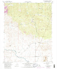
1962 Map of Little Table Mountain
USGS Topo · Published 1981About this map
The San Joaquin Experimental Range occupies the northeastern reaches of this landscape, characterized by a series of cattle stations and ranching outposts. Historic waypoints like Twentytwo Mile House and Bates Station mark the established routes through the foothills, while the Madera Canal cuts through the southern terrain near Four Corners. The map documents a period of land management and water infrastructure development, showing the Siphon and various ranch holdings such as Wide Awake Ranch, Shaubach Ranch, and Urrutia Ranch. Topographical landmarks including Adobe Hill and the prominent Little Table Mountain dominate the local relief. The presence of a small Cem and isolated Quarry sites suggests the localized industries and family legacies that defined this portion of Madera County in the mid-20th century.
Find a feature on this map
23 named features on this map. Tap any name to fly to it.
Don’t see what you’re looking for? This feature index may not catch every label — zoom into the map to look around manually.
Map Details
Editions of this 1962 Little Table Mountain Map
4 editions found
Other maps of this area

1912 · Mariposa
USGS Topo · 1:125,000

1916 · Sulphur Springs
USGS Topo · 1:24,000

1919 · Sulphur Springs
USGS Topo · 1:31,680

1919 · Little Table Mountain
USGS Topo · 1:31,680

1921 · Daulton
USGS Topo · 1:31,680

1922 · Lanes Bridge
USGS Topo · 1:31,680

1922 · Friant
USGS Topo · 1:31,680

1922 · Gregg
USGS Topo · 1:31,680

1942 · Raymond
USGS Topo · 1:62,500

1942 · Daulton
USGS Topo · 1:24,000