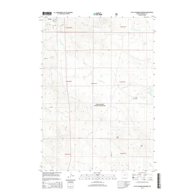
2015 Map of Little Thunder Reservoir
USGS Topo · Published 2015About this map
Thunder Basin National Grassland dominates this portion of Campbell County, where the high plains are carved by a network of seasonal drainages. In the northwest corner, the developing edge of Wright appears with a residential street grid including Story Ave and Duffy Rd. The landscape is defined by its water management and topography, notably Little Thunder Reservoir and Stuart Reservoir, which serve this arid grazing land. Prominent elevations like Black Butte and Gray Butte rise above the surrounding terrain, while deep incisions such as Nicholson Draw and Black Butte Draw guide the flow of Little Thunder Creek and its tributaries. This 2015 survey provides a modern view of the land use patterns and infrastructure in a region where wide-open ranching country meets localized community growth.
Find a feature on this map
29 named features on this map. Tap any name to fly to it.
Don’t see what you’re looking for? This feature index may not catch every label — zoom into the map to look around manually.
Map Details
Editions of this 2015 Little Thunder Reservoir Map
This is the sole edition of this map. No revisions or reprints were ever made.
Other maps of this area

1955 · Newcastle
USGS Topo · 1:250,000

1958 · Newcastle
USGS Topo · 1:250,000

1959 · North Star School
USGS Topo · 1:62,500

1960 · Turnercrest
USGS Topo · 1:62,500

1971 · Teckla
USGS Topo · 1:24,000

1971 · Reno Junction
USGS Topo · 1:24,000

1971 · Reno Reservoir
USGS Topo · 1:24,000

1971 · Little Thunder Reservoir
USGS Topo · 1:24,000

1971 · Teckla SW
USGS Topo · 1:24,000
1971 · Hilight
USGS Topo · 1:24,000