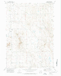
1971 Map of Hilight
USGS Topo · Published 1975About this map
The Hilight Oil and Gas Field dominates this central Campbell County landscape, illustrating the industrial footprint of Wyoming's energy sector during the early 1970s. The specialized Hilight Gas Plant sits at the northern edge of the field, connected by a network of pipelines and service roads like Keeline Road and Little Thunder Road. Despite the heavy industrial presence, traditional ranching continues on the surface, evidenced by landmarks such as Springen Ranch and Jacobs Ranch.
Find a feature on this map
19 named features on this map. Tap any name to fly to it.
Don’t see what you’re looking for? This feature index may not catch every label — zoom into the map to look around manually.
Map Details
Editions of this 1971 Hilight Map
2 editions found
Other maps of this area

1955 · Newcastle
USGS Topo · 1:250,000

1958 · Newcastle
USGS Topo · 1:250,000

1971 · Open A Ranch
USGS Topo · 1:24,000

1971 · Rough Creek
USGS Topo · 1:24,000

1971 · Reno Junction
USGS Topo · 1:24,000

1971 · Reno Reservoir
USGS Topo · 1:24,000

1971 · Piney Canyon NW
USGS Topo · 1:24,000

1971 · Little Thunder Reservoir
USGS Topo · 1:24,000
1971 · Eagle Rock
USGS Topo · 1:24,000
1972 · Neil Butte
USGS Topo · 1:24,000