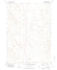
1971 Map of Eagle Rock
USGS Topo · Published 1975About this map
Osborn Ranch sits in the northern reaches of this high plains landscape in Campbell County, where the drainage patterns of the Belle Fourche River and Rattlesnake Creek define the topography. By the early 1970s, the region was undergoing a significant industrial shift as the Hilight Oil and Gas Field expanded across the southern half of the map. Numerous Oil Wells and a central Pipeline indicate the intensifying extraction efforts of the era, contrasting with the traditional ranching heritage of the area. Notable landmarks like Eagle Rock and the winding course of Hay Creek provide natural orientation points amidst the developing energy infrastructure. The map also records early supporting facilities such as a Pumping Sta and a Gravel Pit, reflecting the physical changes brought by resource development in Wyoming's Powder River Basin region.
Find a feature on this map
14 named features on this map. Tap any name to fly to it.
Don’t see what you’re looking for? This feature index may not catch every label — zoom into the map to look around manually.
Map Details
Editions of this 1971 Eagle Rock Map
This is the sole edition of this map. No revisions or reprints were ever made.
Other maps of this area

1954 · Gillette
USGS Topo · 1:250,000

1955 · Newcastle
USGS Topo · 1:250,000

1955 · Gillette
USGS Topo · 1:250,000

1958 · Gillette
USGS Topo · 1:250,000

1958 · Newcastle
USGS Topo · 1:250,000

1959 · North Star School
USGS Topo · 1:62,500

1962 · Gillette
USGS Topo · 1:250,000

1971 · Scaper Reservoir
USGS Topo · 1:24,000

1971 · The Gap SW
USGS Topo · 1:24,000

1971 · Reno Junction
USGS Topo · 1:24,000