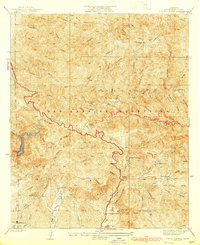
1939 Map of Little Tujunga
USGS Topo · Published 1939About this map
The San Gabriel Mountains north of Los Angeles are defined here by a series of high-altitude ranches and specialized institutions during the late 1930s. The landscape is marked by the presence of the Fairview Sanatorium and I.O.F. Sanatorium in the south, reflecting the era's reliance on mountain air for medical recovery. Deep in the canyons, family holdings like De Mille Ranch, Dillon Ranch, and Watts Ranch suggest a period of active high-country habitation before modern development altered the region's land use.
Find a feature on this map
57 named features on this map. Tap any name to fly to it.
Don’t see what you’re looking for? This feature index may not catch every label — zoom into the map to look around manually.
Map Details
Editions of this 1939 Little Tujunga Map
3 editions found
Other maps of this area

1900 · Fernando
USGS Topo · 1:62,500

1901 · Southern California Sheet No. 1
USGS Topo · 1:250,000

1904 · Southern California Sheet No. 1
USGS Topo · 1:250,000

1925 · Sylmar
USGS Topo · 1:24,000
1926 · Sunland
USGS Topo · 1:24,000
1927 · Pacoima
USGS Topo · 1:24,000
1928 · La Crescenta
USGS Topo · 1:24,000

1928 · Sylmar
USGS Topo · 1:24,000
1929 · Sylmar
USGS Topo · 1:24,000

1929 · Lang
USGS Topo · 1:24,000