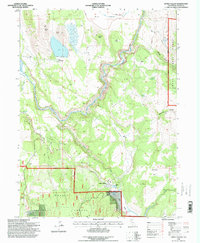
1995 Map of Little Valley
USGS Topo · Published 1998About this map
Little Valley sits at the southern edge of this mid-1990s survey, marking a small pocket of settlement at the confluence of several seasonal drainages. The landscape is defined by the transition from the volcanic heights of Fourth Butte and Third Butte down into the broad, managed basins of Muck Valley. Water management is central to the area's layout, with the Pit River winding through the center, supported by local catchments like Spring Gulch Res and Loomis Reservoir.
Find a feature on this map
28 named features on this map. Tap any name to fly to it.
Don’t see what you’re looking for? This feature index may not catch every label — zoom into the map to look around manually.
Map Details
Editions of this 1995 Little Valley Map
This is the sole edition of this map. No revisions or reprints were ever made.
Other maps of this area

1886 · Lassen Peak
USGS Topo · 1:250,000

1886 · Modoc Lava Bed
USGS Topo · 1:250,000

1892 · Modoc Lava-Bed
USGS Topo · 1:250,000

1892 · Lassen Peak
USGS Topo · 1:250,000

1894 · Lassen Peak
USGS Topo · 1:250,000

1939 · Halls Flat
USGS Topo · 1:125,000

1954 · Alturas
USGS Topo · 1:250,000

1955 · Westwood
USGS Topo · 1:250,000

1957 · Little Valley
USGS Topo · 1:62,500

1957 · Jellico
USGS Topo · 1:62,500