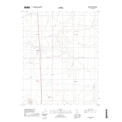
2020 Map of Little Water
USGS Topo · Published 2020About this map
Little Water serves as the primary settlement hub in this 2020 landscape of the Shiprock Agency region. The terrain is defined by dramatic geological markers, including the prominent heights of Ford Butte and Bennett Peak, which stand as landmarks across the desert expanse. Hydrology in this arid environment is characterized by ephemeral drainages such as Sanostee Wash, Tocito Wash, and Coal Cr, all tracing the natural runoff patterns of the basin toward the Peña Blanca Arroyo in the south. The presence of Tocito Lake provides a rare permanent water feature in a geography otherwise dominated by wide washes and high desert terrain. A network of dedicated routes, including Indian SVC Rte 5000 and Indian SVC Rte 5092, connects the dispersed inhabitants of this high-elevation plateau.
Find a feature on this map
21 named features on this map. Tap any name to fly to it.
Don’t see what you’re looking for? This feature index may not catch every label — zoom into the map to look around manually.
Map Details
Editions of this 2020 Little Water Map
This is the sole edition of this map. No revisions or reprints were ever made.
Other maps of this area

1889 · Chaco
USGS Topo · 1:250,000

1892 · Chaco
USGS Topo · 1:250,000

1927 · Sulphur Spring
USGS Topo · 1:96,000

1928 · Kirtland
USGS Topo · 1:125,000

1932 · Kirtland
USGS Topo · 1:125,000

1934 · Ship Rock
USGS Topo · 1:62,500

1937 · Ship Rock
USGS Topo · 1:62,500

1953 · Sanostee
USGS Topo · 1:62,500

1954 · Shiprock
USGS Topo · 1:250,000

1958 · Shiprock
USGS Topo · 1:250,000