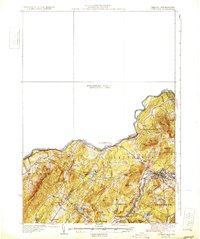
1931 Map of Littleton
USGS Topo · Published 1931About this map
The Connecticut River forms the state boundary on this survey, highlighting the corridor of the Boston and Maine railroad as it parallels the Ammonoosuc River through the village of Littleton. This 1929 topographic study was compiled in part from aerial photographs by the Army Air Corps, a notable early use of the technology to map the complex terrain of Grafton County. The landscape is dotted with local landmarks of genealogical value, including family-named heights like Eustis Hill and Walker Mtn, alongside several rural schoolhouses such as North Monroe Sch and North Lisbon Sch. The map also captures the early automotive era with the Dartmouth College Road State Highway winding past Partridge Lake and Ogontz Lake. A significant portion of the sheet remains marked as a Preliminary Edition Unsurveyed Area, reflecting the transitional state of federal mapping in the New England uplands between the world wars.
Find a feature on this map
48 named features on this map. Tap any name to fly to it.
Don’t see what you’re looking for? This feature index may not catch every label — zoom into the map to look around manually.
Map Details
Editions of this 1931 Littleton Map
2 editions found
Other maps of this area

1900 · Whitefield
USGS Topo · 1:62,500

1920 · Guildhall
USGS Topo · 1:62,500

1929 · Moosilauke
USGS Topo · 1:62,500

1929 · Franconia
USGS Topo · 1:62,500

1931 · Guildhall
USGS Topo · 1:48,000

1931 · Littleton
USGS Topo · 1:62,500

1931 · Woodsville
USGS Topo · 1:48,000

1932 · Franconia
USGS Topo · 1:62,500

1932 · Littleton
USGS Topo · 1:48,000

1932 · Moosilauke
USGS Topo · 1:62,500