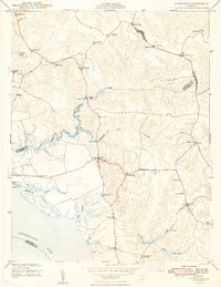
1948 Map of Litwalton
USGS Topo · Published 1948About this map
Lively and Litwalton anchor this survey of Virginia's Northern Neck shortly after the Second World War. The map details a landscape deeply connected to its coastal hydrology, where Lancaster Creek and Mulberry Creek carve through the peninsula toward the wide Rappahannock River. Local industry and community life are marked by water-side landmarks like Griffins Landing and Blakemore Mill, alongside an established network of country houses of worship including Norwood Ch and Bethel Ch.
Find a feature on this map
35 named features on this map. Tap any name to fly to it.
Don’t see what you’re looking for? This feature index may not catch every label — zoom into the map to look around manually.
Map Details
Editions of this 1948 Litwalton Map
2 editions found
Other maps of this area

1916 · Kilmarnock
USGS Topo · 1:48,000

1917 · Heathsville
USGS Topo · 1:48,000

1917 · Urbanna
USGS Topo · 1:62,500

1917 · Morattico
USGS Topo · 1:62,500

1917 · Kilmarnock
USGS Topo · 1:62,500

1918 · Morattico
USGS Topo · 1:62,500

1926 · Morattico
USGS Topo · 1:62,500

1942 · Kilmarnock
USGS Topo · 1:62,500

1943 · Richmond
USGS Topo · 1:250,000

1944 · Morattico
USGS Topo · 1:31,680