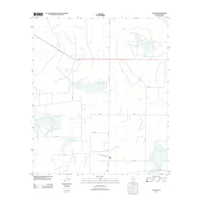
2013 Map of Live Oak
USGS Topo · Published 2013About this map
Brady Cr and Middle Kickapoo Cr carve through this Concho County landscape, which is defined by extensive water management infrastructure. The presence of multiple Soil Conservation Service reservoirs, such as Soil Conservation Service Site 33 Reservoir and Soil Conservation Service Site 30 Reservoir, indicates a territory heavily engineered for flood control and livestock support. The settlement of Live Oak serves as a local point of reference, centered near the Live Oak Cem and the intersection of Ranch Road 176 and Private Road 2330. This network of country roads and ranching tracks connects isolated homesteads to the primary thoroughfare of U.S. Route 87, which cuts across the northwest. For the researcher, the map documents the modern rural layout where natural drainages like Harden Br and Fitzgerald Cr meet artificial impoundments, illustrating the adaptation of West Texas ranch land to the demands of water conservation.
Find a feature on this map
25 named features on this map. Tap any name to fly to it.
Don’t see what you’re looking for? This feature index may not catch every label — zoom into the map to look around manually.
Map Details
Editions of this 2013 Live Oak Map
This is the sole edition of this map. No revisions or reprints were ever made.
Other maps of this area

1892 · San Angelo
USGS Topo · 1:125,000

1892 · Eden
USGS Topo · 1:125,000

1896 · Eden
USGS Topo · 1:125,000

1954 · Brownwood
USGS Topo · 1:250,000

1954 · San Angelo
USGS Topo · 1:250,000

1957 · Eola
USGS Topo · 1:62,500

1958 · San Angelo
USGS Topo · 1:250,000

1965 · San Angelo
USGS Topo · 1:250,000

1967 · Millersview SE
USGS Topo · 1:24,000
1967 · Millersview SW
USGS Topo · 1:24,000