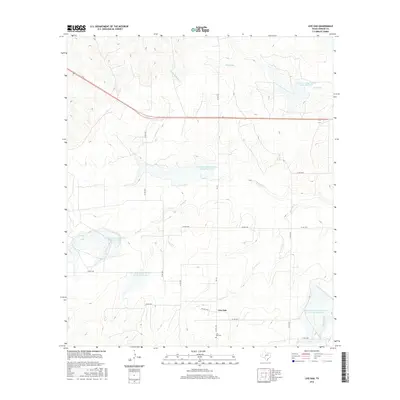
2016 Map of Live Oak
USGS Topo · Published 2016About this map
Live Oak and its surrounding ranch lands appear here as a landscape defined by water management and drainage in central Texas. The settlement itself is centered near the intersection of Co Rd 2324 and Co Rd 2335, with the Live Oak Cem located just to the north. This area of Concho County is characterized by a series of engineered water bodies, including the Soil Conservation Service Site 32 Reservoir and Soil Conservation Service Site 33 Reservoir, which serve to control runoff into the larger creek systems. These waterways, including Brady Cr, Live Oak Cr, and Middle Kickapoo Cr, carve through the terrain, illustrating the critical nature of water resources for the local agricultural economy. The network of county roads like Co Rd 2041 and Co Rd 2202 provides a clear view of how rural properties were partitioned and accessed in the early twenty-first century.
Find a feature on this map
25 named features on this map. Tap any name to fly to it.
Don’t see what you’re looking for? This feature index may not catch every label — zoom into the map to look around manually.
Map Details
Editions of this 2016 Live Oak Map
This is the sole edition of this map. No revisions or reprints were ever made.
Other maps of this area

1892 · San Angelo
USGS Topo · 1:125,000

1892 · Eden
USGS Topo · 1:125,000

1896 · Eden
USGS Topo · 1:125,000

1954 · Brownwood
USGS Topo · 1:250,000

1954 · San Angelo
USGS Topo · 1:250,000

1957 · Eola
USGS Topo · 1:62,500

1958 · San Angelo
USGS Topo · 1:250,000

1965 · San Angelo
USGS Topo · 1:250,000

1967 · Millersview SE
USGS Topo · 1:24,000
1967 · Millersview SW
USGS Topo · 1:24,000