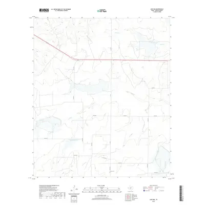
2019 Map of Live Oak
USGS Topo · Published 2019About this map
Live Oak Cem stands as a focal point for genealogical interest in this part of Concho County, situated along the southern reaches of this West Texas landscape. The 2019 survey reveals an environment shaped by water management and ranching infrastructure, with the Soil Conservation Service Site 33 Reservoir and Soil Conservation Service Site 30 Reservoir illustrating the region's efforts to control drainage into local watersheds. These man-made features interact with the natural courses of Brady Cr and Middle Kickapoo Cr, which carve through the terrain. A network of local roads such as FM 176 and Co RD 2041 provides access to remote acreage, while U.S. Route 87 serves as the primary corridor through the northern section of the quadrangle, connecting the rural holdings between ephemeral drainages like Harden Br and Fitzgerald Cr.
Find a feature on this map
21 named features on this map. Tap any name to fly to it.
Don’t see what you’re looking for? This feature index may not catch every label — zoom into the map to look around manually.
Map Details
Editions of this 2019 Live Oak Map
This is the sole edition of this map. No revisions or reprints were ever made.
Other maps of this area

1892 · San Angelo
USGS Topo · 1:125,000

1892 · Eden
USGS Topo · 1:125,000

1896 · Eden
USGS Topo · 1:125,000

1954 · Brownwood
USGS Topo · 1:250,000

1954 · San Angelo
USGS Topo · 1:250,000

1957 · Eola
USGS Topo · 1:62,500

1958 · San Angelo
USGS Topo · 1:250,000

1965 · San Angelo
USGS Topo · 1:250,000

1967 · Millersview SE
USGS Topo · 1:24,000
1967 · Millersview SW
USGS Topo · 1:24,000