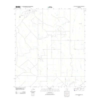
2012 Map of Live Oak Hollow
USGS Topo · Published 2012About this map
Live Oak Hollow and Ezzell Camp anchor this interior South Texas landscape, defined by a network of drainage creeks and concentrated petroleum extraction. The terrain is marked by the presence of the Ezzell Oil Field in the northwest and the Clayton Oil Field to the northeast, reflecting the region's long-standing energy economy. Local transport is facilitated by a grid of county roads, including Co RD-110, Co RD-112, and Co Line RD, which navigate around a dense system of seasonal waterways. This drainage network includes the prominent Live Oak Cr, White Cr, and Rex Cabaniss Cr, which flow through the chaparral and pasture land. In the southern portion of the quadrangle, Leopard Br and Hackberry Cr indicate the subtle topographic shifts that characterize this part of Live Oak County. The map provides a clear record of rural land divisions and the infrastructure required to support industrial activity in a sparsely populated environment.
Find a feature on this map
24 named features on this map. Tap any name to fly to it.
Don’t see what you’re looking for? This feature index may not catch every label — zoom into the map to look around manually.
Map Details
Editions of this 2012 Live Oak Hollow Map
This is the sole edition of this map. No revisions or reprints were ever made.
Other maps of this area

1920 · Mikeska
USGS Topo · 1:125,000

1925 · Simmons No. 1
USGS Topo · 1:48,000

1925 · Simmons No. 2
USGS Topo · 1:48,000

1927 · Oakville
USGS Topo · 1:62,500

1929 · Simmons
USGS Topo · 1:62,500

1953 · Crystal City
USGS Topo · 1:250,000

1955 · Crystal City
USGS Topo · 1:250,000

1961 · Crystal City
USGS Topo · 1:250,000
1963 · Elm Creek
USGS Topo · 1:24,000
1963 · Oakville SW
USGS Topo · 1:24,000