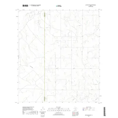
2019 Map of Live Oak Hollow
USGS Topo · Published 2019About this map
Live Oak Hollow and its sister landforms, Mud Hollow and San Caja Hollow, define this corner of South Texas where Live Oak and McMullen counties meet. This 2019 survey captures a landscape primarily shaped by the drainage patterns of seasonal creek beds like White Creek and Live Oak Creek. The area is characterized by its rural infrastructure, with a grid of county roads such as County Road 124 and County Road 123 providing access to the expansive terrain between larger watercourses like Rex-Cabaniss Creek and Hackberry Creek. The border between McMullen and Live Oak counties runs vertically through the center of the sheet, marked as County Line Road, illustrating how political boundaries and transport corridors align in this cattle and oil-producing region of the Brush Country.
Find a feature on this map
24 named features on this map. Tap any name to fly to it.
Don’t see what you’re looking for? This feature index may not catch every label — zoom into the map to look around manually.
Map Details
Editions of this 2019 Live Oak Hollow Map
This is the sole edition of this map. No revisions or reprints were ever made.
Other maps of this area

1920 · Mikeska
USGS Topo · 1:125,000

1925 · Simmons No. 1
USGS Topo · 1:48,000

1925 · Simmons No. 2
USGS Topo · 1:48,000

1927 · Oakville
USGS Topo · 1:62,500

1929 · Simmons
USGS Topo · 1:62,500

1953 · Crystal City
USGS Topo · 1:250,000

1955 · Crystal City
USGS Topo · 1:250,000

1961 · Crystal City
USGS Topo · 1:250,000
1963 · Elm Creek
USGS Topo · 1:24,000
1963 · Oakville SW
USGS Topo · 1:24,000