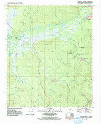
1992 Map of Livengood A-2 SE
USGS Topo · Published 1992About this map
Chatanika River flows through this interior Alaskan landscape, which reflects a century of gold-rush legacy and cold-war infrastructure. The map documents numerous historic mining sites and camps including Old Chatanika, Vault, and Eldorado Camp, many situated along the complex drainage network of Little Eldorado Creek and Dome Creek. A prominent industrial feature is the Davidson Ditch (Abandoned), a massive hydraulic engineering project once used to provide water for gold mining operations. The southern portion of the sheet is marked by the presence of the Trans-Alaska Pipeline, cutting across the terrain north of Pedro Dome. This intersection of early 20th-century mining history and modern energy transportation is further complicated by scientific installations like the Eielson Alaska Long Period Array Research Site, highlighting the strategic and mineral value of the region late in the twentieth century.
Find a feature on this map
44 named features on this map. Tap any name to fly to it.
Don’t see what you’re looking for? This feature index may not catch every label — zoom into the map to look around manually.
Map Details
Editions of this 1992 Livengood A-2 SE Map
This is the sole edition of this map. No revisions or reprints were ever made.
Other maps of this area

1945 · Livengood
USGS Topo · 1:250,000

1949 · Fairbanks D-1
USGS Topo · 1:62,500

1949 · Fairbanks D-2
USGS Topo · 1:62,500

1950 · Fairbanks
USGS Topo · 1:250,000

1951 · Fairbanks
USGS Topo · 1:250,000

1951 · Livengood
USGS Topo · 1:250,000

1952 · Fairbanks D-2
USGS Topo · 1:63,360
1952 · Fairbanks D-1
USGS Topo · 1:63,360

1952 · Fairbanks
USGS Topo · 1:250,000

1952 · Livengood A-2
USGS Topo · 1:63,360