
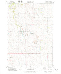
1978 Map of Livermant Lake
USGS Topo · Published 1979About this map
Redwater Creek meanders through the heart of this central Dewey County landscape, which is entirely contained within the Cheyenne River Indian Reservation. Surveyed in the late 1970s, the terrain is defined by its water features, notably the namesake Livermant Lake and the nearby Horseshoe Lake. The northern edge of the map follows the course of the Moreau river, where the presence of a Golf Course suggests the localized development occurring near the Firesteel township line. The map illustrates a transitional period for the reservation’s land use, showing a sparse network of roads and section lines connecting these isolated water bodies across the prairie.
Find a feature on this map
6 named features on this map. Tap any name to fly to it.
Don’t see what you’re looking for? This feature index may not catch every label — zoom into the map to look around manually.
Map Details
Editions of this 1978 Livermant Lake Map
This is the sole edition of this map. No revisions or reprints were ever made.
Other maps of this area

1952 · Parade NE
USGS Topo · 1:24,000

1952 · Lantry NE
USGS Topo · 1:24,000

1952 · Parade NW
USGS Topo · 1:24,000

1953 · McIntosh
USGS Topo · 1:250,000

1958 · McIntosh
USGS Topo · 1:250,000

1978 · Brewer Butte
USGS Topo · 1:24,000

1978 · Timber Lake
USGS Topo · 1:24,000

1978 · Peach Lake
USGS Topo · 1:24,000

1978 · Little Moreau Lake
USGS Topo · 1:24,000
1978 · Firesteel
USGS Topo · 1:24,000