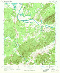
1967 Map of Livingston
USGS Topo · Published 1970About this map
Horseleg Mountain rises prominently over the river landscape where the Coosa River feeds into the Weiss Reservoir. This late 1960s environment shows a distinct intersection of natural topography and mid-century industrial water management, including a Pumping Sta and the Mayo Bar Dam Gaging Station. Small rural settlements like Livingston, Vans Valley, and Cunningham are scattered throughout the valley, connected by a network of winding roads such as Blacks Bluff Road and Livingston Road. Local history is deeply rooted in the community sites mapped here, including the Flat Rock Cem and several country churches like Bush Arbor Ch and Cedar Creek Ch. The Southern Railway cuts through the southern terrain near Vans Valley, serving as a primary transportation artery alongside traditional river bends like Camp Bend and Turner Bend.
Find a feature on this map
49 named features on this map. Tap any name to fly to it.
Don’t see what you’re looking for? This feature index may not catch every label — zoom into the map to look around manually.
Map Details
Editions of this 1967 Livingston Map
2 editions found
Other maps of this area

1886 · Rome
USGS Topo · 1:125,000

1898 · Rome
USGS Topo · 1:125,000

1899 · Rome
USGS Topo · 1:125,000

1904 · Rome
USGS Topo · 1:125,000

1955 · Rome
USGS Topo · 1:250,000

1958 · Rome
USGS Topo · 1:250,000

1961 · Rome
USGS Topo · 1:250,000

1963 · Rome
USGS Topo · 1:250,000
1967 · Rock Mountain
USGS Topo · 1:24,000
1967 · Cedartown West
USGS Topo · 1:24,000