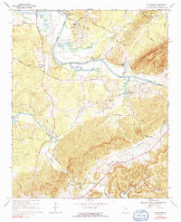
1967 Map of Livingston
USGS Topo · Published 1991About this map
The Coosa River defines the landscape of western Floyd County, winding past Livingston and through sharp bends like Turner Bend and Camp Bend. This mid-century view shows the river’s relationship with Weiss Lake, which pushes into the valley as an backwater reservoir, influencing local drainage along Hamilton Creek. The mapping captures a transition from river-bottom agriculture to more industrial uses, noted by the Industrial Waste Pond and multiple gravel pits near the northern reaches.
Find a feature on this map
47 named features on this map. Tap any name to fly to it.
Don’t see what you’re looking for? This feature index may not catch every label — zoom into the map to look around manually.
Map Details
Editions of this 1967 Livingston Map
2 editions found
Other maps of this area

1886 · Rome
USGS Topo · 1:125,000

1898 · Rome
USGS Topo · 1:125,000

1899 · Rome
USGS Topo · 1:125,000

1904 · Rome
USGS Topo · 1:125,000

1955 · Rome
USGS Topo · 1:250,000

1958 · Rome
USGS Topo · 1:250,000

1961 · Rome
USGS Topo · 1:250,000

1963 · Rome
USGS Topo · 1:250,000
1967 · Rock Mountain
USGS Topo · 1:24,000
1967 · Cedartown West
USGS Topo · 1:24,000