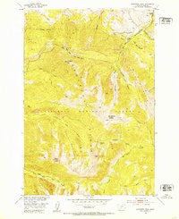
1951 Map of Livingston Peak
USGS Topo · Published 1963About this map
Livingston Peak dominates the high-altitude landscape of the Absaroka Range in this mid-century topographic record. Within the Gallatin National Forest, the terrain is defined by steep drainages and prominent summits like Mount Delano and Elephanthead Mountain. The map illustrates the sparse human footprint in this wilderness area, focusing on established ranching outposts such as Triangles Ranch and the 63 Ranch. Transportation is limited to the Mission Creek Road following the path of Mission Creek, which carves through the central portion of the quadrangle. The map reveals the intricate watershed system feeding into the Missouri River Basin, including Blacktail Lake and the various forks of Deep Creek. This survey captures the transition from the high peaks to the valley floor, providing a precise look at the forest boundaries and natural landmarks used by early surveyors and land managers.
Find a feature on this map
28 named features on this map. Tap any name to fly to it.
Don’t see what you’re looking for? This feature index may not catch every label — zoom into the map to look around manually.
Map Details
Editions of this 1951 Livingston Peak Map
5 editions found
Other maps of this area

1891 · Livingston
USGS Topo · 1:250,000

1893 · Livingston
USGS Topo · 1:250,000

1940 · Mt. Cowen
USGS Topo · 1:62,500

1943 · Mt Cowen
USGS Topo · 1:62,500

1947 · Bozeman
USGS Topo · 1:250,000

1948 · Bozeman
USGS Topo · 1:250,000

1951 · Mount Rae
USGS Topo · 1:24,000

1951 · Brisbin
USGS Topo · 1:24,000

1951 · Livingston Peak
USGS Topo · 1:24,000

1951 · Elton
USGS Topo · 1:24,000