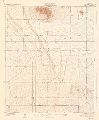
1934 Map of Llano
USGS Topo · Published 1934About this map
Llano serves as the primary settlement in this part of the Antelope Valley, appearing during a period of agricultural experimentation in the high desert. The landscape is dominated by the broad, braided course of Big Rock Wash, which descends toward the valley floor from the south. This 1930s-era topography reveals a transition from the prominent heights of the Lovejoy Buttes in the north to the gradually rising alluvial fan toward the southern mountains. Cultural development is concentrated along the Palmdale Victorville Road, which cuts across the southern portion of the quadrangle. Local infrastructure is defined by a rigid grid of unpaved thoroughfares like Avenue and Blossom St E, alongside numerous irrigation wells that highlight the region's reliance on groundwater for settlement. The presence of the Desert Relief station near the settlement of Llano points to the importance of this route for travel across the arid Mojave landscape.
Find a feature on this map
10 named features on this map. Tap any name to fly to it.
Don’t see what you’re looking for? This feature index may not catch every label — zoom into the map to look around manually.
Map Details
Editions of this 1934 Llano Map
4 editions found
Other maps of this area

1901 · Southern California Sheet No. 1
USGS Topo · 1:250,000

1903 · Rock Creek
USGS Topo · 1:62,500

1904 · Southern California Sheet No. 1
USGS Topo · 1:250,000

1930 · Lovejoy Springs
USGS Topo · 1:24,000

1930 · Black Butte
USGS Topo · 1:24,000

1930 · Little Rock
USGS Topo · 1:24,000

1930 · Llano
USGS Topo · 1:24,000

1930 · West Alpine Butte
USGS Topo · 1:24,000

1930 · Wilsona
USGS Topo · 1:24,000

1933 · Lovejoy Springs
USGS Topo · 1:24,000