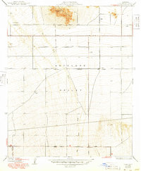
1934 Map of Llano
USGS Topo · Published 1949About this map
Antelope Valley's high desert landscape is defined here by the intersection of early ranching and developing aeronautical infrastructure during the 1930s and 1940s. Centered around the drainage of Big Rock Wash, the map illustrates a transition from traditional land use at the Lewis Ranch to the modern demands of civil aviation, signaled by the presence of an Airway Beacon atop Lovejoy Buttes. The strict grid of the First Standard Parallel North and numbered roads like Avenue Q and 170 th St E reveal a landscape precisely surveyed for expansion, even where settlement remained sparse. At the southern edge, the Llano PO serves as a vital community hub along Palmdale Avenue, providing a glimpse into the localized network of post offices and desert wells that supported life in this corner of Los Angeles County before widespread suburbanization.
Find a feature on this map
16 named features on this map. Tap any name to fly to it.
Don’t see what you’re looking for? This feature index may not catch every label — zoom into the map to look around manually.
Map Details
Editions of this 1934 Llano Map
4 editions found
Other maps of this area

1901 · Southern California Sheet No. 1
USGS Topo · 1:250,000

1903 · Rock Creek
USGS Topo · 1:62,500

1904 · Southern California Sheet No. 1
USGS Topo · 1:250,000

1930 · Lovejoy Springs
USGS Topo · 1:24,000

1930 · Black Butte
USGS Topo · 1:24,000

1930 · Little Rock
USGS Topo · 1:24,000

1930 · Llano
USGS Topo · 1:24,000

1930 · West Alpine Butte
USGS Topo · 1:24,000

1930 · Wilsona
USGS Topo · 1:24,000

1933 · Lovejoy Springs
USGS Topo · 1:24,000