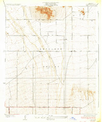
1934 Map of Llano
USGS Topo · Published 1934About this map
Lovejoy Buttes rise sharply from the floor of the Antelope Valley, serving as a primary landmark in this 1930s high desert landscape. The survey captures a sparsely populated region where early infrastructure began to define the High Desert's connectivity, anchored by the tiny settlement of Llano in the southeast. Water management is visibly critical to the area's survival, evidenced by scattered wells and the prominent diagonal course of Big Rock Wash which cuts through the arid terrain.
Find a feature on this map
12 named features on this map. Tap any name to fly to it.
Don’t see what you’re looking for? This feature index may not catch every label — zoom into the map to look around manually.
Map Details
Editions of this 1934 Llano Map
4 editions found
Other maps of this area

1901 · Southern California Sheet No. 1
USGS Topo · 1:250,000

1903 · Rock Creek
USGS Topo · 1:62,500

1904 · Southern California Sheet No. 1
USGS Topo · 1:250,000

1930 · Lovejoy Springs
USGS Topo · 1:24,000

1930 · Black Butte
USGS Topo · 1:24,000

1930 · Little Rock
USGS Topo · 1:24,000

1930 · Llano
USGS Topo · 1:24,000

1930 · West Alpine Butte
USGS Topo · 1:24,000

1930 · Wilsona
USGS Topo · 1:24,000

1933 · Lovejoy Springs
USGS Topo · 1:24,000