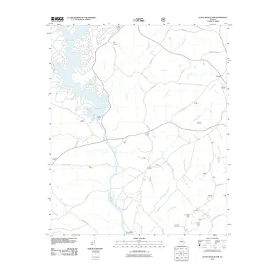
2011 Map of Lloyd Shoals Dam
USGS Topo · Published 2011About this map
Lloyd Shoals Dam controls the waters where the Ocmulgee River begins its southward course, shaping the complex fingers of Jackson Lake in this part of Georgia. This 2011 survey illustrates a rural landscape defined by creek drainages such as Hardys Creek and Kinnard Creek, where family and community heritage is preserved in numerous small burial grounds. Genealogists can locate Leverette Cemetery, Mount Zion Cemetery, and Minter Cemetery among others. The transition from the developed lakefront near Roberts Point Rd to the wooded tracts of Concord Hunt Camp and Rush Creek Hunt Camp highlights the area's dual character as a recreational destination and a managed timberland. Settlements like Bethel and Tyler Crossroads serve as focal points for a network of historic routes, including Thomas Ferry Rd and Giles Ferry Rd, which speak to the area's long history of river crossings.
Find a feature on this map
56 named features on this map. Tap any name to fly to it.
Don’t see what you’re looking for? This feature index may not catch every label — zoom into the map to look around manually.
Map Details
Editions of this 2011 Lloyd Shoals Dam Map
This is the sole edition of this map. No revisions or reprints were ever made.
Other maps of this area

1951 · Forsyth
USGS Topo · 1:62,500

1953 · Athens
USGS Topo · 1:250,000

1958 · Athens
USGS Topo · 1:250,000

1959 · Athens
USGS Topo · 1:250,000

1963 · Athens
USGS Topo · 1:250,000

1964 · Lloyd Shoals Dam
USGS Topo · 1:24,000
1964 · Jackson
USGS Topo · 1:24,000

1964 · Stewart
USGS Topo · 1:24,000

1964 · Hillsboro
USGS Topo · 1:24,000

1964 · Worthville
USGS Topo · 1:24,000