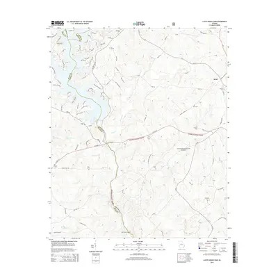
2014 Map of Lloyd Shoals Dam
USGS Topo · Published 2014About this map
Jackson Lake dominates the northwest portion of this landscape, its indented fingers reaching into the surrounding wooded terrain where the boundaries of Butts, Jasper, and Newton counties converge. The area east of the lake is characterized by the expansive Oconee National Forest, which covers a significant portion of the territory. The settlement of Bethel sits in the northeast, connected by a network of winding roads like Bethel Church Rd. For genealogists, the map is remarkably dense with family-named burial sites, including the Leverette Cem, Minter Cem, and Maddox Cem. The drainage patterns are defined by numerous creeks such as Herds Creek and Wise Creek, which flow through the protected forest lands. Distinctive river features like Scout Island and Forty Acre Island are also visible, marking the geographic character of the waterway system.
Find a feature on this map
97 named features on this map. Tap any name to fly to it.
Don’t see what you’re looking for? This feature index may not catch every label — zoom into the map to look around manually.
Map Details
Editions of this 2014 Lloyd Shoals Dam Map
This is the sole edition of this map. No revisions or reprints were ever made.
Other maps of this area

1951 · Forsyth
USGS Topo · 1:62,500

1953 · Athens
USGS Topo · 1:250,000

1958 · Athens
USGS Topo · 1:250,000

1959 · Athens
USGS Topo · 1:250,000

1963 · Athens
USGS Topo · 1:250,000

1964 · Lloyd Shoals Dam
USGS Topo · 1:24,000
1964 · Jackson
USGS Topo · 1:24,000

1964 · Stewart
USGS Topo · 1:24,000

1964 · Hillsboro
USGS Topo · 1:24,000

1964 · Worthville
USGS Topo · 1:24,000