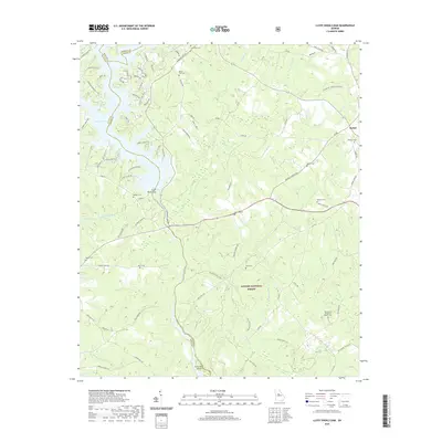
2020 Map of Lloyd Shoals Dam
USGS Topo · Published 2020About this map
Lloyd Shoals Dam stands at the heart of this landscape, regulating the waters where Jackson Lake transitions into the Ocmulgee River. This modern survey reveals a region defined by its hydrography and forestry, with the southern reaches protected within the Oconee National Forest. The map is particularly valuable for genealogists, as it meticulously identifies numerous small family and community burial grounds, including the Fellowship Primitive Baptist Cem and Mount Zion Cem. The settlement of Bethel anchors the northeastern corner, while the surrounding terrain is carved by complex creek systems such as Herds Creek and Kinnard Creek. The residential development around the lake contrasts sharply with the managed timberlands to the south, showcasing the evolving land use near the Newton, Butts, and Jasper county lines.
Find a feature on this map
98 named features on this map. Tap any name to fly to it.
Don’t see what you’re looking for? This feature index may not catch every label — zoom into the map to look around manually.
Map Details
Editions of this 2020 Lloyd Shoals Dam Map
This is the sole edition of this map. No revisions or reprints were ever made.
Other maps of this area

1951 · Forsyth
USGS Topo · 1:62,500

1953 · Athens
USGS Topo · 1:250,000

1958 · Athens
USGS Topo · 1:250,000

1959 · Athens
USGS Topo · 1:250,000

1963 · Athens
USGS Topo · 1:250,000

1964 · Lloyd Shoals Dam
USGS Topo · 1:24,000
1964 · Jackson
USGS Topo · 1:24,000

1964 · Stewart
USGS Topo · 1:24,000

1964 · Hillsboro
USGS Topo · 1:24,000

1964 · Worthville
USGS Topo · 1:24,000