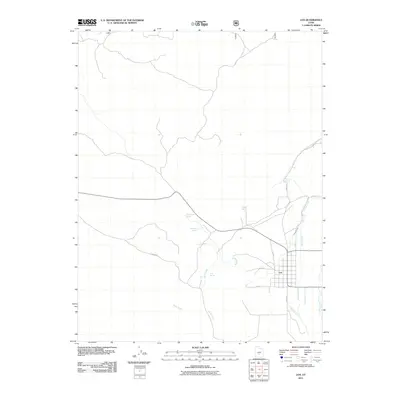
2011 Map of Loa
USGS Topo · Published 2011About this map
Loa serves as the focal point of this Wayne County landscape, situated where the high-elevation valleys meet the life-giving waters of the Fremont River. The settlement's grid is clearly defined by local thoroughfares like S Main St and W 100 N, while its agricultural reliance is evident through the path of the Loa Town Ditch. This 2011 survey details a complex water management system essential to the arid climate, tracing the courses of Road Creek and Spring Creek as they drain toward the valley floor.
Find a feature on this map
18 named features on this map. Tap any name to fly to it.
Don’t see what you’re looking for? This feature index may not catch every label — zoom into the map to look around manually.
Map Details
Editions of this 2011 Loa Map
This is the sole edition of this map. No revisions or reprints were ever made.
Other maps of this area

1885 · Fish Lake
USGS Topo · 1:250,000

1896 · Fish Lake
USGS Topo · 1:250,000

1952 · Loa 1 SE
USGS Topo · 1:24,000

1952 · Loa 1 NE
USGS Topo · 1:24,000

1956 · Salina
USGS Topo · 1:250,000

1960 · Salina
USGS Topo · 1:250,000

1962 · Salina
USGS Topo · 1:250,000

1967 · Lyman
USGS Topo · 1:24,000

1968 · Fish Lake
USGS Topo · 1:24,000
1968 · Burrville
USGS Topo · 1:24,000