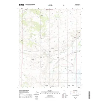
2020 Map of Loa
USGS Topo · Published 2020About this map
Loa sits at the heart of this high-altitude landscape, serving as the seat of local government as marked by the Wayne County Courthouse. The town's layout is defined by a grid of streets that transition into irrigation systems like the Loa-Town Ditch and Fremont Loa Ditch, which channel water from the Fremont River to sustain the local agriculture. To the north, the terrain rises toward the Fishlake National Forest, where features such as Little Mtn and Row of Pines Bench overlook the valley. The map documents numerous springs and hollows that define the watershed, including Dog Spring and Sheep Hollow. Cultural landmarks such as Loa Cem and Fremont Cem provide critical points of reference for genealogists, while the presence of the Awapa Plateau and Rabbit Valley highlights the distinct geographic character of this corner of the state.
Find a feature on this map
66 named features on this map. Tap any name to fly to it.
Don’t see what you’re looking for? This feature index may not catch every label — zoom into the map to look around manually.
Map Details
Editions of this 2020 Loa Map
This is the sole edition of this map. No revisions or reprints were ever made.
Other maps of this area

1885 · Fish Lake
USGS Topo · 1:250,000

1896 · Fish Lake
USGS Topo · 1:250,000

1952 · Loa 1 SE
USGS Topo · 1:24,000

1952 · Loa 1 NE
USGS Topo · 1:24,000

1956 · Salina
USGS Topo · 1:250,000

1960 · Salina
USGS Topo · 1:250,000

1962 · Salina
USGS Topo · 1:250,000

1967 · Lyman
USGS Topo · 1:24,000

1968 · Fish Lake
USGS Topo · 1:24,000
1968 · Burrville
USGS Topo · 1:24,000