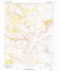
1969 Map of Loa
USGS Topo · Published 1973About this map
Loa serves as the focal point of this high-plateau landscape, situated within the fertile stretch of Rabbit Valley. The settlement pattern follows a traditional grid, surrounded by evidence of early infrastructure including a Radio Facility, Rodeo Grounds, and the Loa Cem. To the north, the terrain rises into the Fishlake National Forest, where features like The Ledges and the Awapa Plateau define the geography. This 1960s survey documents a vital water network essential for high-altitude agriculture and conservation, showcasing the Fremont River and its various tributaries. The presence of a Fish Hatchery near Spring Creek and the numerous springs, such as Riley Canyon Spring and Bullberry Spring, highlights the community's reliance on these upland water sources. Local history is further preserved through landmarks like Allred Point and the Fremont Cem, while the extensive system of jeep trails through Rock Hollow and Sheep Hollow indicates the historical access routes into the surrounding backcountry.
Find a feature on this map
42 named features on this map. Tap any name to fly to it.
Don’t see what you’re looking for? This feature index may not catch every label — zoom into the map to look around manually.
Map Details
Editions of this 1969 Loa Map
2 editions found
Other maps of this area

1885 · Fish Lake
USGS Topo · 1:250,000

1896 · Fish Lake
USGS Topo · 1:250,000

1952 · Loa 1 SE
USGS Topo · 1:24,000

1952 · Loa 1 NE
USGS Topo · 1:24,000

1956 · Salina
USGS Topo · 1:250,000

1960 · Salina
USGS Topo · 1:250,000

1962 · Salina
USGS Topo · 1:250,000

1967 · Lyman
USGS Topo · 1:24,000

1968 · Fish Lake
USGS Topo · 1:24,000
1968 · Burrville
USGS Topo · 1:24,000