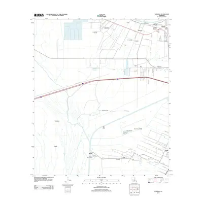
2012 Map of Lobdell
USGS Topo · Published 2012About this map
Allendale and Westover are central to this landscape in West Baton Rouge Parish, where historical plantation names and industrial infrastructure coexist. The map shows a region shaped by extractive industries and transportation, featuring the Lobdell Oil and Gas Field and the Port Allen Oil Field alongside the artificial course of the Port Allen Canal. Several family and community burial grounds, including Allendale Cem, Westover Cem, and the Greater Shiloh Missionary Cem, provide critical points of interest for genealogists tracing local lineage in these unincorporated communities. To the south, the settlement of Brusly sits near the Choctaw Basin Drainage Canal, illustrating the complex water management required in this low-lying territory. From the rural outposts of Morley and Lynch to the active waterways of Alligator BYU and Whisky Bay, the map documents a distinct Louisiana corridor defined by its agricultural roots and its 21st-century role in energy production.
Find a feature on this map
81 named features on this map. Tap any name to fly to it.
Don’t see what you’re looking for? This feature index may not catch every label — zoom into the map to look around manually.
Map Details
Editions of this 2012 Lobdell Map
This is the sole edition of this map. No revisions or reprints were ever made.
Other maps of this area

1906 · Bayou Sara
USGS Topo · 1:125,000

1908 · Baton Rouge
USGS Topo · 1:62,500

1939 · Zachary
USGS Topo · 1:62,500

1939 · Baton Rouge
USGS Topo · 1:62,500

1940 · Grosse Tete
USGS Topo · 1:62,500

1953 · Baton Rouge West
USGS Topo · 1:24,000

1953 · Plaquemine
USGS Topo · 1:24,000

1953 · Lobdell
USGS Topo · 1:24,000

1953 · Addis
USGS Topo · 1:24,000

1953 · Grosse Tete SW
USGS Topo · 1:24,000