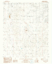
1990 Map of Lobo Hill
USGS Topo · Published 1990About this map
Lobo Hill rises as a prominent landmark above the drainage patterns of Torrance County, anchoring a landscape defined by water management and resource extraction in the late twentieth century. This arid New Mexico terrain is crisscrossed by a significant infrastructure network, including an extensive Pipeline and a centrally located Pumping Sta, reflecting the importance of liquid transport in the high plains. The map traces the natural flow of the Cañada de la Puerta, Salt Draw, and Big Draw, which carve through the topography and dictate the placement of ranching or industrial outposts. Local industrial activity is evidenced by scattered Borrow Pits and a Borrow Pit near the northern boundary. Genealogists and local historians can use this survey to pinpoint specific water sources like Cottonwood Well, which often served as vital hubs for homesteading and livestock in this environment.
Find a feature on this map
9 named features on this map. Tap any name to fly to it.
Don’t see what you’re looking for? This feature index may not catch every label — zoom into the map to look around manually.
Map Details
Editions of this 1990 Lobo Hill Map
This is the sole edition of this map. No revisions or reprints were ever made.
Other maps of this area

1892 · San Pedro
USGS Topo · 1:125,000

1894 · Lamy
USGS Topo · 1:125,000

1917 · Estancia
USGS Topo · 1:125,000

1954 · Santa Fe
USGS Topo · 1:250,000

1954 · Fort Sumner
USGS Topo · 1:250,000

1954 · Socorro
USGS Topo · 1:250,000

1956 · Edgewood
USGS Topo · 1:62,500

1956 · Estancia
USGS Topo · 1:62,500

1958 · Socorro
USGS Topo · 1:250,000

1958 · Fort Sumner
USGS Topo · 1:250,000