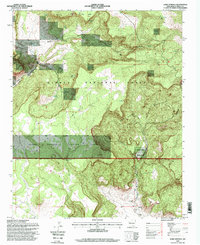
1995 Map of Lobo Springs
USGS Topo · Published 1998About this map
La Jara Mesa and the San Mateo Mountains dominate this high-altitude landscape in the mid-1990s. The map illustrates a complex boundary between the Cibola National Forest and Acoma Pueblo Indian Land, marked by the National Forest and Indian Land Boundary. Evidence of earlier resource extraction is visible at the Coal Mine (Abandoned) located near Lobo Canyon, while the Tietjen Ranch represents local ranching history.
Find a feature on this map
26 named features on this map. Tap any name to fly to it.
Don’t see what you’re looking for? This feature index may not catch every label — zoom into the map to look around manually.
Map Details
Editions of this 1995 Lobo Springs Map
This is the sole edition of this map. No revisions or reprints were ever made.
Other maps of this area

1883 · Mt. Taylor
USGS Topo · 1:250,000

1886 · Mt. Taylor
USGS Topo · 1:250,000

1892 · Mt. Taylor
USGS Topo · 1:250,000

1899 · Mt. Taylor
USGS Topo · 1:250,000

1957 · Lobo Springs
USGS Topo · 1:24,000

1957 · Mount Taylor
USGS Topo · 1:24,000

1957 · Dos Lomas
USGS Topo · 1:24,000

1957 · Grants SE
USGS Topo · 1:24,000

1957 · Mc Cartys
USGS Topo · 1:24,000

1957 · Cubero
USGS Topo · 1:24,000