
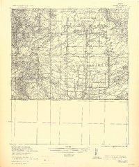
1932 Map of Lochiel
USGS Topo · Published 1932About this map
Lochiel sits directly on the United States Mexico border, anchored by a Double wire fence along Border and a nearby Camp of Troops. This 1932 tactical edition from the Corps of Engineers, U. S. Army details a landscape defined by ranching and high-desert mining. To the west, the Harshaw Hills are pocketed with industrial sites including the World's Fair Mine, Trench Mine, and The Mowry Mine. The central valley is dominated by the San Rafael De La Zanja land grant, where the Santa Cruz River flows through Wild hay Lands. Local genealogists will find numerous family names attached to the terrain, from Stevensons Ranch and Martin's Ranch to the Cananea Land & Cattle Co. (Egans) Ranch. The map also captures the small settlements of Duquesne and Washington, serving as a record of the remote borderlands before modern development.
Find a feature on this map
52 named features on this map. Tap any name to fly to it.
Don’t see what you’re looking for? This feature index may not catch every label — zoom into the map to look around manually.
Map Details
Editions of this 1932 Lochiel Map
2 editions found
Other maps of this area

1904 · Patagonia
USGS Topo · 1:125,000

1905 · Patagonia
USGS Topo · 1:125,000

1905 · Nogales
USGS Topo · 1:125,000

1914 · Hereford
USGS Topo · 1:125,000

1915 · Benson
USGS Topo · 1:125,000

1922 · Agus Caliente
USGS Topo · 1:62,500

1922 · Sunnyside
USGS Topo · 1:62,500

1932 · Elgin
USGS Topo · 1:62,500

1933 · Calabasas
USGS Topo · 1:62,500

1938 · Huachuca
USGS Topo · 1:62,500