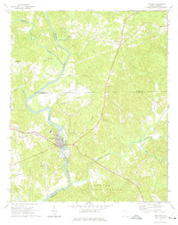
1972 Map of Lockhart
USGS Topo · Published 1975About this map
The Broad River and Pacolet River converge in this northern South Carolina landscape, marking a historic junction where Union, Cherokee, York, and Chester counties meet. At the heart of the river bend lies Pinckneyville, accompanied by a nearby Historical Monument that signifies the area's early role in the state's judicial and political development. Further south, the town of Lockhart serves as a concentrated industrial and residential hub, defined by its position along the riverbank and the Southern railroad line, featuring local infrastructure like a Water Tank and its own Lockhart Chapel.
Find a feature on this map
39 named features on this map. Tap any name to fly to it.
Don’t see what you’re looking for? This feature index may not catch every label — zoom into the map to look around manually.
Map Details
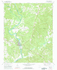
Editions of this 1972 Lockhart Map
2 editions found
Other maps of this area

1907 · Sharon
USGS Topo · 1:62,500

1941 · Spartanburg
USGS Topo · 1:250,000

1953 · Spartanburg
USGS Topo · 1:250,000

1960 · Spartanburg
USGS Topo · 1:250,000

1963 · Spartanburg
USGS Topo · 1:250,000

1964 · Spartanburg
USGS Topo · 1:250,000
1968 · Wilkinsville
USGS Topo · 1:24,000

1969 · Kelton
USGS Topo · 1:24,000

1969 · Baton Rouge
USGS Topo · 1:24,000
1969 · Leeds
USGS Topo · 1:24,000