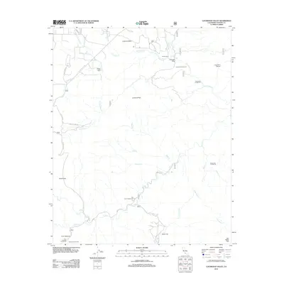
2012 Map of Lockwood Valley
USGS Topo · Published 2012About this map
Lockwood Valley serves as the central focal point of this high-elevation region in Ventura County, where mountain ranching and remote recreation define the landscape. The map captures established properties such as the Lazy T Ranch, Dainton Trumbo Ranch, and Snedden Ranch, highlighting the historical agricultural footprint within the valley. Waterways like Lockwood Cr and Piru Cr carve through the terrain, dictating the placement of primitive roads and campgrounds that cater to those exploring the backcountry. To the south, Mutau Flat provides a significant level area amidst the surrounding peaks, including Lockwood Peak and San Rafael Peak. The abundance of marked sites like Thorn Meadows and Half Moon Campground illustrates the area's transition into a managed wilderness and forest service resource. The mapping of Forest Routes like Forest Rte 7N13 and the Mutau Flat Rd traces the primary access corridors through this complex drainage network.
Find a feature on this map
44 named features on this map. Tap any name to fly to it.
Don’t see what you’re looking for? This feature index may not catch every label — zoom into the map to look around manually.
Map Details
Editions of this 2012 Lockwood Valley Map
This is the sole edition of this map. No revisions or reprints were ever made.
Other maps of this area

1903 · Mt. Pinos
USGS Topo · 1:125,000

1903 · Tejon
USGS Topo · 1:125,000

1942 · Frazier Mountain
USGS Topo · 1:24,000

1943 · Topatopa Mountains
USGS Topo · 1:24,000

1943 · San Guillermo
USGS Topo · 1:24,000

1943 · Sawmill Mountain
USGS Topo · 1:24,000

1943 · Cuddy Valley
USGS Topo · 1:24,000

1943 · Lockwood Valley
USGS Topo · 1:24,000

1943 · Lion Canyon
USGS Topo · 1:24,000
1943 · Devils Heart Peak
USGS Topo · 1:24,000