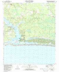
1990 Map of Lockwoods Folly
USGS Topo · Published 1991About this map
The Lockwoods Folly River dominates this coastal landscape, winding through a complex system of marshes and cuts before reaching the Lockwoods Folly Inlet. By the late 1980s, the area shows a distinct contrast between the established fishing and boat-building community of Varnamtown and the burgeoning recreational developments along the coast. The Intracoastal Waterway cuts a straight path behind the barrier islands, separating the mainland from the dense grid of Long Beach and Holden Beach.
Find a feature on this map
46 named features on this map. Tap any name to fly to it.
Don’t see what you’re looking for? This feature index may not catch every label — zoom into the map to look around manually.
Map Details
Editions of this 1990 Lockwoods Folly Map
This is the sole edition of this map. No revisions or reprints were ever made.
Other maps of this area

1943 · Funston
USGS Topo · 1:24,000

1943 · Holden Beach
USGS Topo · 1:24,000

1943 · Bolivia
USGS Topo · 1:24,000

1943 · Lockwoods Folly
USGS Topo · 1:24,000

1943 · Supply
USGS Topo · 1:24,000

1944 · Supply
USGS Topo · 1:31,680

1944 · Bolivia
USGS Topo · 1:31,680

1944 · Lockwoods Folly
USGS Topo · 1:31,680

1946 · Southport
USGS Topo · 1:24,000

1949 · Georgetown
USGS Topo · 1:250,000